Quick answer: Latitude tells how far a location is north or south of the Equator (0° to 90° N or S). Longitude tells how far a location is east or west of the prime meridian (0° to 180° E or W). Together, latitude and longitude form geographic coordinates that help identify locations on Earth. Coordinates are commonly written latitude first, longitude second.
This geography and map-skills lesson for U.S. middle-school students explains how to read coordinates, use hemispheres, convert degrees and minutes, and avoid the most common map mistakes. The definitions follow NOAA’s National Ocean Service educational guide.
Learning goals
- Identify the Equator, prime meridian, latitude and longitude.
- Read degrees north (N), south (S), east (E), and west (W).
- Understand decimal-degree positive and negative signs.
- Convert simple degrees-and-minutes coordinates to decimal degrees.
- Practice locating points without confusing the order of the two numbers.
What is latitude?
Latitude measures a location’s position relative to the Equator. The Equator is 0° latitude. The North Pole is approximately 90° N, and the South Pole 90° S. Imaginary lines of constant latitude are called parallels; on a globe, they run east-west and do not cross each other.
Examples: 40° N means forty degrees north of the Equator; 20° S means twenty degrees south. All U.S. states are north of the Equator. A latitude written without N or S may use a sign: positive for north, negative for south.
What is longitude?
Longitude measures east-west angular position relative to the prime meridian, conventionally associated with Greenwich, England. The prime meridian is 0° longitude. Meridians run from pole to pole; they are farthest apart near the Equator and meet at the poles. The opposite meridian is 180°, sometimes called the antimeridian. In decimal coordinates, west longitude is usually negative and east longitude positive.
For example, 74° W is written −74° in signed decimal notation. The 180° meridian is commonly represented as either +180° or −180° and is not an ordinary east/west pair of separate locations. The International Date Line is roughly associated with this region, but local legal time-zone and date boundaries do not follow it perfectly. NOAA explains these distinctions in its longitude fact sheet.
Latitude vs. longitude: remember the difference
- Latitude lines run east-west but measure north-south position.
- Longitude lines run north-south but measure east-west position.
- Equator: reference for latitude, 0°.
- Prime meridian: reference for longitude, 0°.
- Standard coordinate order: latitude, then longitude.
How to read coordinates step by step
Read the example 40.7° N, 74.0° W.
- First number: latitude 40.7° N tells you the point is north of the Equator.
- Second number: longitude 74.0° W tells you it is west of the prime meridian.
- Signed decimal notation: the same pair can be expressed approximately as (40.7, −74.0).
- Location: this is approximately in the New York City area. It is a rounded teaching example, not an exact building address.
The order matters. Reversing it to (−74.0, 40.7) would describe a completely different location in the Southern and Eastern Hemispheres.
What do the plus and minus signs mean?
In the widely used signed decimal-degree convention, latitude north is positive and south is negative, while longitude east is positive and west is negative. Thus (34, −118) is an approximate Southern California coordinate, while (−34, 118) would be in the Southern and Eastern Hemispheres. A plus sign is often omitted for positive numbers.
How to convert degrees and minutes to decimal degrees
A degree (°) has 60 minutes (′); a minute has 60 seconds (″). To convert degrees and minutes to decimal degrees, calculate degrees + minutes ÷ 60, then apply a negative sign for S or W if using signed decimal coordinates.
Worked example: 40° 42′ N
- 42 ÷ 60 = 0.7.
- 40 + 0.7 = 40.7° N.
- In signed decimal notation, write +40.7° or just 40.7.
Worked example: 74° 15′ W
- 15 ÷ 60 = 0.25.
- 74 + 0.25 = 74.25 degrees.
- West is negative, so the result is −74.25°.
For seconds, add seconds ÷ 3,600 as well. For example, 10° 30′ 36″ N = 10 + 30/60 + 36/3600 = 10.51° N.
Are latitude and longitude degrees the same physical distance?
No. On Earth, one degree of latitude is approximately 111 kilometers (69 miles), with small geographic variation. A degree of longitude covers roughly that distance near the Equator but progressively less toward the poles, where meridians converge. Therefore, a “1° by 1°” map box does not have the same physical width everywhere. Geographic coordinates are angles, not a universal distance grid.
How does GPS use coordinates?
Navigation systems obtain position estimates using satellite signals and calculate a location that can be displayed as latitude and longitude. Phones and online maps often show decimal-degree coordinates, although apps may use different coordinate conventions or map datums. A coordinate with only one decimal place describes a relatively broad area; it should not be treated as an exact doorway. Always verify the map’s coordinate order and format before entering data.
Real Earth photography versus map lines
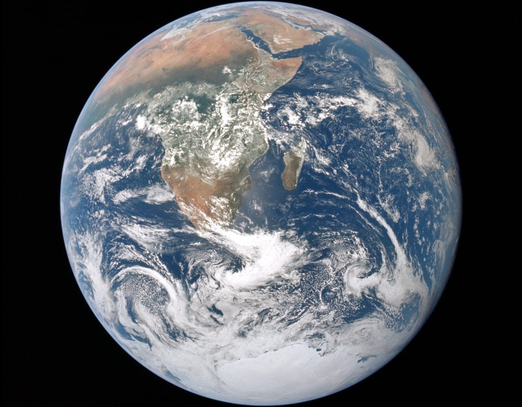
The featured photograph is the genuine Apollo 17 Blue Marble image recorded by NASA astronauts on December 7, 1972, looking toward Earth. It shows Africa, ocean and cloud patterns. Latitude and longitude lines are human-defined reference lines and therefore do not appear in the photograph. NOAA’s educational diagrams are better for seeing the imaginary coordinate grid, and the NASA photograph helps students understand the shape and geography of the planet.
Seven questions to practice
- Which coordinate measures north-south position?
- What is the latitude of the Equator?
- What is the longitude of the prime meridian?
- Which sign represents western longitude in signed decimal degrees?
- In (35.0, −80.0), which number is latitude?
- Convert 20° 30′ S to signed decimal degrees.
- True or false: all lines of longitude stay parallel and never meet.
Answer key
- Latitude.
- 0°.
- 0°.
- Negative (−).
- 35.0°, the first number.
- −20.5° because 30/60 = 0.5 and south is negative.
- False; meridians converge at the poles.
Common errors and a quick checklist
Do not swap latitude and longitude. Do not assume a line’s running direction describes the measurement it provides. Check N/S/E/W signs, the number format (decimal degrees versus degrees-minutes-seconds), and whether the example location is approximate. A correctly written coordinate can still point to the wrong place if its datum, precision or entry order is wrong.
Keep learning
Study Geography & Map Skills, review landscapes in Earth Science & Geology, and explore Space & Astronomy for more real-Earth observations.
Official sources and photograph credit
- NOAA — What Are Latitude and Longitude?
- NOAA — What Is Latitude?
- NOAA — What Is Longitude?
- NASA Scientific Visualization Studio — The Blue Marble from Apollo 17 (actual photograph)
Featured image: NASA Apollo 17 crew, astronaut photograph AS17-148-22727 (December 7, 1972), public-domain U.S. government photograph. The photo does not depict drawn latitude or longitude lines.
Sık Sorulan Sorular
What is the difference between latitude and longitude?
Latitude measures north or south of the Equator; longitude measures east or west of the prime meridian.
Which comes first, latitude or longitude?
Latitude is conventionally written before longitude in many geographic coordinate formats, although some software uses a different order; check the application's convention.
What are the coordinates of New York City?
A rounded example near New York City is approximately 40.7° N, 74.0° W, or (40.7, -74.0); this does not identify a specific address.